from$ 13924 AUD
Note: Current p/p indicative rate. Final price may change due to currency fluctuations.
Ortelius
Ushuaia to Ushuaia
Overview
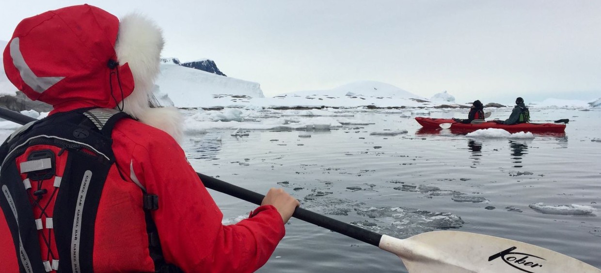
The Antarctic Peninsula Basecamp cruise offers you a myriad of ways to explore and enjoy the Antarctic Region. This expedition allows you to hike, snowshoe, kayak, go mountaineering, and even camp out under the Southern Polar skies. During our “Basecamp” departures, all offered activities (including camping, kayaking, snowshoe/hiking, mountaineering, photo workshop) as well as our standard included shore excursions and zodiac cruises) are free of charge.
Departures
Cruise Itinerary
Your voyage begins where the world drops off. Ushuaia, Argentina, reputed to be the southernmost city on the planet, is located on the far southern tip of South America. Starting in the afternoon, you embark from this small resort town on Tierra del Fuego, nicknamed “The End of the World,” and sail the mountain-fringed Beagle Channel for the remainder of the evening.
Over the next two days on the Drake Passage, you enjoy some of the same experiences encountered by the great polar explorers who first charted these regions: cool salt breezes, rolling seas, maybe even a fin whale spouting up sea spray. After passing the Antarctic Convergence – Antarctica’s natural boundary, formed when north-flowing cold waters collide with warmer sub-Antarctic seas – you are in the circum-Antarctic upwelling zone. Not only does the marine life change, the avian life changes too. Wandering albatrosses, grey-headed albatrosses, black-browed albatrosses, light-mantled sooty albatrosses, cape pigeons, southern fulmars, Wilson’s storm petrels, blue petrels, and Antarctic petrels are a few of the birds you might see.
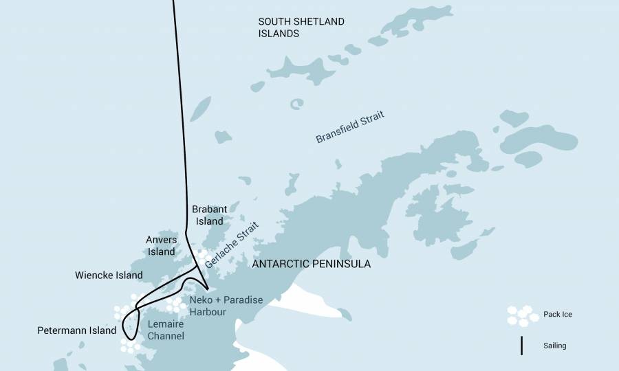
Gray stone peaks sketched with snow, towers of broken blue-white ice, and dramatically different wildlife below and above. You first pass the snow-capped Melchior Islands and Schollaert Channel, sailing between Brabant and Anvers Islands. Places you might visit includes: Neumayer Channel – The vessel may position itself here, launching its multiple basecamp activities from the protected waters around Wiencke Island. You can enjoy the splendors of this alpine environment at sea with Zodiac and kayaking trips, or if you’re in the mood for a walk, there are possible snowshoe hikes and soft-climb mountaineering options farther inland. Naturally, favorable weather conditions determine the possible activities. Port Lockroy – After sailing through the Neumayer Channel, you may get a chance to visit the former British research station – now a museum and post office – of Port Lockroy on Goudier Island. You may also be able to partake in activities around Jougla Point, meeting gentoo penguins and blue-eyed shags. There are great opportunities also for kayaking and camping here, and when conditions are right, you can even snowshoe around the shore. Pléneau & Petermann Islands – If the ice allows it, you can sail through the Lemaire Channel in search of Adélie penguins and blue-eyed shags. There’s also a good chance you’ll encounter humpback and minke whales here, as well as leopard seals. Kayaking, glacier walks, and more ambitious mountaineering trips are the potential activities of this location. Neko Harbour – An epic landscape of mammoth glaciers and endless wind-carved snow, Neko Harbour offers opportunities for a Zodiac cruise and landing that afford the closest views of the surrounding alpine peaks. Paradise Bay – You have the chance to make camp here like a true polar explorer (but with a better tent), enjoying a supreme overnight Antarctic adventure. Errera Channel – Possible sites in this area include Danco Island and Cuverville Island, but also the lesser known (though equally picturesque) Orne Island and Georges Point on Rongé Island. On your last day of near-shore activities, you pass the Melchior Islands toward the open sea. Keep a sharp lookout for humpback whales in Dallmann Bay. You might also shoot for Half Moon Island, in the South Shetlands, with further chances for activities. Conditions on the Drake Passage determine the exact time of departure.
Your return voyage is far from lonely. While crossing the Drake, you’re again greeted by the vast array of seabirds remembered from the passage south. But they seem a little more familiar to you now, and you to them.
Every adventure, no matter how grand, must eventually come to an end. It’s now time to disembark in Ushuaia, but with memories that will accompany you wherever your next adventure lies.
All itineraries are for guidance only. Programs may vary depending on local ice, weather, and wildlife conditions. The on-board expedition leader will determine the final itinerary. Flexibility is paramount for expedition cruises.
Ortelius
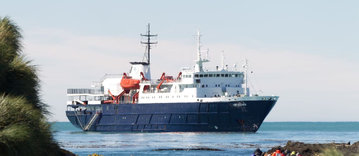
Vessel Type: Expediton Length: 91m Passenger Capacity: 108-123 Built / Refurbished : 1989 / 2015 The vessel has the highest ice-class notation (UL1, equivalent to 1A) and is therefor suitable to navigate in solid one-year sea ice as well as loose multi-year pack ice. Ortelius can accommodate up to 116-123 passengers (108 passengers as of season Arctic 2020) and has an abundance of open-deck spaces. It is manned by 22 highly experienced nautical crew members, 19 hotel staff, eight expedition specialists (one expedition leader, one assistant, and six lecturer-guides), and one doctor. Though our voyages are primarily meant to offer our passengers an exploratory wildlife program with as much time ashore as possible, Ortelius offers all the comforts of a standard hotel ― along with a bar and lecture room. Flexibility assures maximum wildlife opportunities. As such, Ortelius carries 10 Zodiacs with 60hp Yamaha engines.
Highlights
• Camping • Kayaking • Mountaineering • Paradise Bay • Photo Workshop • Pléneau Island • Snowshoeing • Zodiac Cruising & Shore program
Map