

from$ 28500 AUD
Note: Current p/p indicative rate. Final price may change due to currency fluctuations.
Silver Cloud
Dublin to Kangerlussuaq
Overview
Enjoy this in-depth, insightful combination cruise that shows you a side of northern Europe that you have never seen. Starting in Ireland’s sing-song capital, sail to Scotland’s big skies, ancient architecture, spectacular wildlife, superb seafood and hospitable, down-to-earth locals. A day at sea brings you to Iceland and its jaw dropping natural beauty. Sail on to Greenland for an off the beaten adventure, aided by your friendly expedition team.
Departures
Cruise Itinerary
Atmospheric cobbled streets, with buskers scraping fiddles and characterful pubs inviting passersby inside, is Dublin in a snapshot. A city of irrepressible energy and lust for life, Ireland's capital is as welcoming a place as you'll find. Horse-drawn carriages plod along cobbled centuries-old streets, blending with an easy-going, cosmopolitan outlook. Known for its fun-filled gathering of pubs, any excuse works to enjoy a celebratory toast and chat among good company. Home to perhaps the world's most famous beer - slurp perfect pourings of thick, dark Guinness - cranked out for the city's thirsty punters. Learn more of the humble pint's journey at the Guinness Storehouse. Dublin has come along way since the Vikings established a trading port here, back in the 9th Century. In the time since, the city became the British Empire's defacto second city, and the Georgian imprint still adds oodles of historic character. Learn of 1916's Easter Uprising, when the Irish rebelled and established their independence here, as you visit the infamous, haunting Kilmainham Gaol. The uprising's leaders were tried and executed in these dark confines. Dublin's St. Patrick's Cathedral has immense history below its steep spire, which dates back to 1191. There's rich literary heritage to leaf through too, and the city's streets were rendered vividly in James Joyce's classic Ullyses. The Museum of Literature celebrates the full scope of Dublin's lyrical talents. Trinity College also has a prestigious roll-call of alumni - visit to see the Book of Kells, a beautifully illustrated bible of the medieval era.
Portrush is adjacent to the stunning North Antrim coastline. Here lies the medieval Dunluce Castle ruins. Perched picturesquely at the edge of a rocky outcropping high above the sea, the castle is dramatically surrounded by terrifyingly steep drops, which the early Christians and Vikings would have considered a very important security feature. The castle and surrounding areas have been frequently used for the filming of “Game of Thrones”. Another attraction reached from Portrush is the Giant’s Causeway -40,000 hexagonal basalt columns that descend in a kind of pathway to the sea. Formed over 50 million years ago, visitors have marvelled at its majesty and mystery for centuries, and UNESCO has recognised this site with World Heritage status.
Near the southern end of the Isle of Skye lies Loch Skarvaig. Open to the sea, the sheltered Loch penetrates the rounded granite hills of Skye. Heather moorlands grow on the hill slopes, with purple flowering heathers providing colour, starting in Spring and climaxing later in summer. Common Seals, otherwise known as Harbour Seals, are frequently seen swimming in the coastal water at high tides. Only their heads are visible as they take breaths between diving for a meal of fish, crustaceans or molluscs. At low tides the seals are easier to see, resting on the foreshore rocks. When ashore, Common Seals often lie on one side with their hind flippers and heads raised in a shallow U shape like oversized spotted grey bananas. There are about 300 Common Seals living in and around Loch Coriusk. Skye also has a population of larger Grey Seals with long straight noses. Although all seals are protected now, they were once hunted for their skins, which were used to make clothes and for sporrans to accompany kilts. Considered the shortest river in Britain, Scavaig River or River Coruisk empties into Loch Scavaig. At only a few hundred metres long, it connects to the freshwater of Loch Coruisk. This freshwater loch collects run-off from the hills and overflows down the bends of the river to the sea of Loch Scavaig. Lying close together, the two lochs can look similar at high tide but they have totally different life. The saltwater kelps and shellfish of Loch Scavaig’s shores are revealed at low tide. Many different groups of people have lived on the small Canna Isle. Neolithic people settled thousands of years ago. Later, Christian Celtic monks, Norse settlers and various Scottish groups lived on Canna. Evidence of most are still present, notably stone churches. One unusual relic is a standing stone with a hole above people’s heads in which the thumb of a lawbreaker was jammed. The accused was left for a time to reflect on his or her deeds. Canna is one of the Little Isles group of the Inner Hebrides. A bridge connects it to the adjacent Sanday Island. Both islands are small, with a tiny resident population. Today, the island is managed by the National Trust of Scotland. Compass Hill, 139 metres (456 feet) high, is a prominent landmark. It is named after the high iron content of the tuff—consolidated volcanic ash—makes up the hill. This attracted the needles of compasses on nearby ships causing confusion to pre-satellite navigators. The hill slopes have a variety of wildflowers that take advantage of good soils, and warm springs and summers. Canna is a bird sanctuary, with 15,000 breeding seabirds of 14 species. Half of the birds are Common Guillemots who nest on cliff ledges. A long-term National Trust bird ringing study has found guillemots live for a long time, with the oldest ever recorded for Britain being a 38 -year-old bird on Canne. As well as abundant seabirds, we may see scarcer birds including birds of prey. The majestic White-tailed Sea-eagle is one to look out for.
Skye epitomizes Scotland's wild celtic appeal. A turbulent geological history has given this beautiful, rugged island some of Britain's most varied and dramatic scenery. Steeped in mystery, romance and adventure, the Isle of Skye is perhaps the most well-known of Scotland's many islands. Charles Edward Stuart, better known as Bonnie Prince Charlie, escaped here from the mainland disguised as a maidservant of a woman by the name of Flora MacDonald. The north of the island is dominated by a rugged volcanic plateau, the south by the Cuillins mountain range, whose peaks were sculpted by the glaciers of the Ice Age. Skye is divided by numerous sea lochs allowing continuous proximity to the sea. The limestone grasslands of the south are the home of sheep and cattle. Scattered about are ruins of crofts, small holdings used for grazing; they were abandoned as their owners fell into poverty due to lack of income. Dunvegan is situated in a sheltered sea loch, or fjord, on the northwestern coast of the island on the Waternish peninsula. The small settlement is dominated by Dunvegan Castle. The oldest inhabited castle in Scotland, it has been the seat of the chiefs of the Clan MacLeod for the past 700 years. It offers insights into Scotland's clan spirit with paintings and relics from the MacLeod Clan. The gardens were originally laid out in the 18th century and are of considerable interest with the woodland glades, shimmering pools and a multitude of rhododendrons. Loch Dunvegan is home to a seal colony; the two main varieties are the brown seal and the great gray Atlantic seal. Small local boats depart from the jetty at frequent intervals throughout the day enabling close observation of these playful sea mammals.
Exploring the sandstone cliff faces of the Isle of Noss will reveal ledges loaded with gannets, puffins, guillemots, shags, kittiwakes, Razorbills, fulmars and Great Skuas. The island was recognized as a National Nature Reserve in 1955, and has one of Europe’s largest and most diverse seabird colonies. Sheep have grazed the inland hillsides of Noss since the late 1800s and early 1900s when around twenty people lived on the island to manage the sheep farm. Along with the sheep, shaggy Shetland ponies graze the windblown slopes of Noss. Adrift between the Scottish and Norwegian coasts, the craggy Shetland Islands form the most northerly point of the British Isles. Sprawling across 100 islands, connected by sandy bridges and crisscrossing ferries, explore the highlights of this scenic archipelago outpost. With incredible Neolithic history, spanning 5,000 years of human heritage, these islands, which sit just shy of the Arctic Circle, are an isolated and immense treasure trove of history and thrilling scenery. Look out over dramatic coastline from atmospheric Iron Age towers. Sweeping, windswept beaches and wisps of sand connect islands and rugged cliffs - stand back as the sounds of the waves smashing against the shore and calling gulls fills the air. The islands are also home to some of the most adorable four-legged creatures you’ll ever meet, the diminutive and wavy-fringed, Shetland Ponies who roam the hills and reach a maximum size of 42 inches. Don't be fooled, though, they are amongst the strongest and toughest of all breeds. Their existence here points to Viking history, as local horses bred with ponies brought ashore by Norse settlers, creating the lovable crossbreed that is an icon of these islands today. The towering Broch of Mousa is perhaps Europe’s best-preserved Iron Age building - and one of the Shetland's finest brochs - a series of round, stone towers, believed to have been constructed around 100 BC. Seals and birdlife ensure that the isolated islands are always well-populated with life - and you can embark on hikes to discover their coastal homes. Lerwick is the islands’ capital, and there's a charming welcome on offer, as you arrive before the waterfront of stone buildings, which cascade down to the shore.
Scattered just off the northern tip of Scotland, Kirkwall is the capital of the Orkney Islands - a scenic archipelago of fascinating, dual heritage. The Viking influence is deep, while a prehistoric past and World War history adds to the endless stories that these dramatic islands have to tell. Sparse and beautiful, let the sweeping seascapes of frothing waves, and dance of the northern lights, enchant you as you explore. Windswept beaches are inhabited by whooping swans, while grassy cliffs hide puffins amid their wavy embrace. Sea caves and crumbling castles - and the dramatic meeting of the North Sea and the Atlantic Ocean add to the romantic beauty of these lands, which may be physically close to the UK, but feel an entire world away. The sandstone St. Magnus Cathedral is the centrepiece of Orkney's main town - a place of winding lanes and atmospheric walks - and Britain's northernmost cathedral is a masterpiece that took 300 years to complete. Started in 1137, the beautiful cathedral is adorned with mesmerising stain-glass windows and has been evocatively named as the Light of the North. Look down over the ruined Bishop’s and Earl’s Palaces nearby from the tip of the cathedral's tower. Or, test out the islands' history-rich distilleries, which produce smokey single malts - said to be the best in the world. You can also venture out to Europe's best-preserved Stone Age Village, at the extraordinary World Heritage Site of Skara Brae, which offers an unparalleled vision into prehistoric life.
Gloriously remote, St. Kilda is an archipelago 50 miles off the Isle of Harris. Although the four islands are uninhabited by humans, thousands of seas birds call these craggy cliffs home, clinging to the sheer faces as if by magic. Not only is St. Kilda home to the UK’s largest colony of Atlantic Puffin (almost 1 million), but also the world largest colony Gannets nests on Boreray island and its sea stacks. The islands also home decedents of the world’s original Soay sheep as well as having a breed of eponymously named mice. The extremely rare St. Kilda wren unsurprisingly hails from St. Kilda, so birders should visit with notebook, binoculars and camera to hand. While endemic animal species is rife on the island, St. Kilda has not been peopled since 1930 after the last inhabitants voted that human life was unsustainable. However, permanent habitation had been possible in the Medieval Ages, and a vast National Trust for Scotland project to restore the dwellings is currently being undertaken. The islands even enjoyed a status as being an ideal holiday destination in the 19th century. Today, the only humans living on the islands are passionate history, science and conservation scholars. One of the caretakers even acts as shopkeeper and postmaster for any visitors who might like to send a postcard home from St. Kilda. It should be noted that St. Kilda is the UKs only (and just one of 39 in the world) dual World Heritage status from UNESCO in recognition of its Natural Heritage and cultural significance. As an isolated island of the remote St Kilda Group, Boreray island is one of the most far flung and weather impacted islands of the North East Atlantic. Imagine trying to live here during stormy weather. Landing requires jumping or swimming ashore; and yet the island has been lived on or visited from Neolithic times. Collecting seabirds and their eggs, and storing them for winter, may have been even more important than raising sheep. Boreray Sheep are the rarest breed of sheep in Britain. They evolved from short-tailed sheep brought from the Scottish mainland but have been isolated long enough to have evolved into a distinctive small and horned breed. Only found on Boreray Island, they remained as a wild flock when the last people left the St Kilda Islands in 1930. The Souy are a separate and different breed of sheep found on the other St Kilda Islands. Look out for the Boreray Sheep grazing on the slopes of hilly Boreray Island. Seabirds thrive on Boreray and its two attendant rocks stacks, raising new chicks each summer. Northern Gannets glide overhead as they attempt difficult landings at nest sites. Seeing gannets plunge from a great height into the sea is an exciting way to understand the effort required to feed themselves and chicks. Northern Fulmers nest on the volcanic rock cliffs and Atlantic Puffins fly in and out of burrow-strewn slopes. Boreray is part of the St Kilda World Heritage Site, a rare example of a site recognised for both its outstanding natural and cultural values.
Days at sea are the perfect opportunity to relax, unwind and catch up with what you’ve been meaning to do. So whether that is going to the gym, visiting the spa, whale watching, catching up on your reading or simply topping up your tan, these blue sea days are the perfect balance to busy days spent exploring shore side.
Slow the pace and discover the refreshing approach to life that Djupivogur has made its trademark. You can leave your phone behind as you step out into this Icelandic town, which has won awards celebrating its leisurely outlook and stubborn rebellion against the frenetic pace of modern life. After all, who needs emails and notifications when you have some of the most humbling monochrome scenery and gashed fjords, waiting on your doorstep? Sitting on a peninsula to the south-east of Iceland, the glacial approach to life here wins many hearts. A place where hammers knock on metal in workshops, artists ladle paint onto canvases, and where you might spot a few Icelandic horses roaming across mountains, Djupivogur is an uninhibited artistic hub - full of makers and creatives. The most expansive project is the 34 egg sculptures that dot the coastline, created by the Icelandic artist, Sigurður Guðmundsson. Each egg represents a different native bird species. Fishing remains the primary industry, and you can savour the soft fruits of the labour in restaurants serving up smoked trout and fish soup within their cosy confines. Wander the surrounding landscapes, where snow-freckled mountains rise, and lazy seals lie on dark rock beaches, to feel Djupivogur's natural inspiration seeping under your skin. Alive with greens and golds in summer, further ventures reveal glaciers and the sprawling waterfalls of Vatnajökull National Park. The cliff-hugging puffins of Papey Island are a must see, while Bulandstindur Mountain's pyramid shape is a stand out even among these fairy-tale landscapes.
The name Vestmannaeyjar refers to both a town and an archipelago off the south coast of Iceland. The largest Vestmannaeyjar island is called Heimaey. It is the only inhabited island in the group and is home to over 4000 people. The eruption of the Eldfell Volcano put Vestmannaeyjar into the international lime light in 1973. The volcano’s eruption destroyed many buildings and forced an evacuation of the residents to mainland Iceland. The lava flow was stopped in its tracks by the application of billions of liters of cold sea water. Since the eruption, life on the small island outpost has returned to the natural ebb and flow of a small coastal fishing community on the edge of the chilly and wild North Atlantic. On 14 November 1963, a trawler passing the southernmost point of Iceland spotted a column of smoke rising from the sea. Expecting to find a burning boat they were surprised to find instead, explosive volcanic eruptions. They were witnessing the birth of a new island. Columns of ash reached heights of almost 30,000 feet in the sky and could be seen on clear days as far away as Reykjavík. The eruptions continued for three and a half years, ending in June 1967. Once formed, Surtsey was 492 feet above sea level and covered an area of almost 2 square miles. The island was named after the Norse fire god Surtur. It is a perfect scientific study area used to understand the colonization process of new land by plant and animal life.
The capital of Iceland’s land of ice, fire and natural wonder, Reykjavik is a city like no other - blossoming among some of the world’s most vibrant and violent scenery. Home to two-thirds of Iceland’s population, Reykjavik is the island’s only real city, and a welcoming and walkable place - full of bicycles gliding along boulevards or battling the wind when it rears up. Fresh licks of paint brighten the streets, and an artistic and creative atmosphere embraces studios and galleries - as well as the kitchens where an exciting culinary scene is burgeoning. Plot your adventures in the city's hip bars and cosy cafes, or waste no time in venturing out to Iceland’s outdoor adventures. Reykjavik’s buildings stand together in a low huddle - below the whip of winter’s winds - but the magnificent Hallgrímskirkja church is a solid exception, with its bell tower rising resolutely over the city. Iceland’s largest church's design echoes the lava flows that have shaped this remote land and boasts a clean and elegant interior. The Harpa Concert Hall’s sheer glass facade helps it to assimilate into the landscape, mirroring back the city and harbour. Its LED lights shimmer in honour of Iceland’s greatest illuminated performance – the northern lights. Walk in the crusts between continents, feel the spray from bursts of geysers and witness the enduring power of Iceland’s massive waterfalls. Whether you want to sizzle away in the earth-heated geothermal pools, or hike to your heart’s content, you can do it all from Reykjavik - the colourful capital of this astonishing outdoor country.
Days at sea are the perfect opportunity to relax, unwind and catch up with what you’ve been meaning to do. So whether that is going to the gym, visiting the spa, whale watching, catching up on your reading or simply topping up your tan, these blue sea days are the perfect balance to busy days spent exploring shore side.
Located on Greenland’s relatively rarely visited rugged east coast, Skoldungen Fjord has enchanting scenery with towering mountains tipped with snow, ice-scraped valley sides and sculptured icebergs in shades of white and blue. At the top of the fjord one can easily see the retreating state of the Thrym Glacier. The U-shaped fjord offers spectacular scenery and as an extra perk, it is not uncommon to see whales in the fjord.
The transit through the Sound is one of this voyage’s highlights. Connecting the Labrador Sea with the Irminger Seat, Prince Christian Sound or “Prins Christian Sund” in Danish is named after Prince (later King) Christian VII (1749-1808). 100 km (60 miles ), long and at times just 500 m (1500 ft) wide, this majestic and spectacular fiord throws you back into a Viking era – flanked by soaring snow-topped mountains, rock-strewn cliffs and rolling hills, it is as if time has stood still and one easily forgets that this is the 21st century. As you marvel at the sheer size of the mountains that surround you, with the Arctic waters lapping deceptively at the hull, revel in the silence enveloping you. Icebergs float serenely by, carrying with them the ages of time. Be sure to wear warm clothing as this is one spectacle that you do not want to miss. If you’re looking for remote and remarkable then you have found it. Cruise through Prince Christian Sound to the western end and you’ll find Aapilattoq, a (very) small Greenlandic village of just 100 inhabitants. The name of the village means “sea anemone” in the local Greenlandic language, and the fact that the village has retained its Inuit name is a good indication of what you can expect; traditional village life much as it has been for the past 100 years. Hunting and fishing are the main occupations here, and it is not unusual when taking a stroll through Aappilattoq, past the small school (where 22 pupils from ages 3-16 are enrolled) and church, to come across a polar bear skin drying in the wind behind a local dwelling. The village is hidden behind a prominent red rock and towering mountains, which make the village virtually inaccessible by land. Naturally, the Aapilattoq and its surrounding area are phenomenally rich in Arctic wildlife: Arctic fox and Arctic hare live in the countryside around the village while marine mammals include ringed seal, harbour seal, hooded seal, bearded seal, harp seal, humpback whale (typically in summer), minke whale, fin whale, narwhal, and beluga.
There is a wonderful legend that the Vikings named Greenland Green and Iceland Ice in order to confuse potential attackers. Because it is quite the opposite; if Iceland is full of emerald forest, then expect ice in Greenland. Lots and lots of ice. Thus one shouldn’t be too surprised to learn that the name Nanortalik means “place of polar bears”. Although, as Nanortalik is Greenland’s most southerly town, don’t be too disappointed if you don’t see any. In truth, Greenland’s polar bears typically live much further north. What you will see however is Mother Nature at her finest. Vertical cliff walls, sheets of floating sea ice and a plethora of Arctic wildlife that amount to an adventurer’s wonderland. As Nanortalik itself is located on a small island in the southern tip of Greenland, nature is never far away, wherever you find yourself. The optimistically named city centre is surrounded by the pristine waters of Tasermiut Fjord and dotted with the colourful houses you would expect this far north. Traditionally, artisans’ houses were painted different colours to showcase what they did, i.e. commercial houses were red; hospitals were yellow; police stations were black; the telephone company was green and fish factories were blue. Today it is more a case of anything goes! Nanortalik locals are warm and welcoming, and are known to extent the art of Kaffe-Mik to its visitors. This old tradition is where a family invites guests into their home to drink coffee and taste their famous Greenlandic cake. In the local Kalaallisut language, Uunartoq means 'hot', and there is no mystery why. Several warm springs exist in Greenland, but Uunartoq Island is the only site where the waters form a pool warm enough to bathe in. Although not as well known as the famous springs of Iceland, nowhere can challenge Uunartoq for scenery. The picturesque series of steaming pools are backed by some of the best scenery Greenland has to offer. Icebergs larger than city blocks drift through the labyrinth of fjords which make up Southern Greenland, passing as they drift towards the ocean. Mountains pierce the clouds, and the tundra blooms in the long summer days; and there is no better way to appreciate the spectacular wilderness of South Greenland than from the perfectly warmed natural comfort of the Uunartoq hot spring. The ancient crystalline rock of Southern Greenland is nearly two billion years old. A fault in the rock allows water to sink down into the ground, where Earth's internal heat warms it, causing it to rise again. Uunartoq Island is the site where this water escapes, forming a sandy pool heated constantly from below. Basic changing facilities and a grass walkway to the stone-lined pool allow visitors comfort, while reconnecting with nature. It is believed that the Norse settlers in Greenland knew of and made use of the pool, but the island has never been inhabited, excluding a few summerhouses belonging to local residents.
The largest town in southern Greenland, Qaqortoq has been inhabited since prehistoric times. Upon arrival in this charming southern Greenland enclave, it's easy to see why. Qaqortoq rises quite steeply over the fjord system around the city, offering breath-taking panoramic vistas of the surrounding mountains, deep, blue sea, Lake Tasersuag, icebergs in the bay, and pastoral backcountry. Although the earliest signs of ancient civilization in Qaqortoq date back 4,300 years, Qaqortoq is known to have been inhabited by Norse and Inuit settlers in the 10th and 12th centuries, and the present-day town was founded in 1774. In the years since, Qaqortoq has evolved into a seaport and trading hub for fish and shrimp processing, tanning, fur production, and ship maintenance and repair. 18 kilometers northeast of Qaqortoq, Hvalsey is part of Qaqortukulooq, one of the five sites of the UNESCO World Heritage Arctic farming complex Kujataa. Between Eriksfjord to the north and Einarsfjord to the south, the Hvalseyfjord branches off from Einarsfjord. Although Hvalsey is better known for the well-preserved ruins of one of the sixteen churches in the Norse’s Eastern Settlement, the church was in a farmstead known as Thjodhild’s Stead. This farmstead at the northeastern end of the fjord included a large building with living quarters, a hall and livestock pens, as well as other livestock pens, a storage building and a warehouse –the ruins of which can still be seen. The Norse farming laid the foundation for the Inuit farming in later centuries, leading to the UNESCO World Heritage status in 2017. In the 14th century account “Descriptions of Greenland” the abundant fish, a reindeer farm on Reindeer Island and Hvalsey’s name “Whale Island” clearly indicate that the Norse had ample food sources at that time. The church was built in the Anglo-Norwegian style of the 13th century, but is known to have been built over an older graveyard. The farmstead is mentioned in the Icelandic “Book of Settlements” as property of the Kings of Norway, and the last documented event of the Norse in Greenland is a wedding which took place in the church in September 1408. After almost 600 years of abandonment, conservation work had to be done to prevent the seaward wall from collapsing.
Days at sea are the perfect opportunity to relax, unwind and catch up with what you’ve been meaning to do. So whether that is going to the gym, visiting the spa, whale watching, catching up on your reading or simply topping up your tan, these blue sea days are the perfect balance to busy days spent exploring shore side.
In the bustling capital city of Greenland, you could be forgiven for forgetting you are in such a vast and isolated country. Nuuk is Greenland's economic and social hub, home to more than a third of Greenland's population, and although it feels like a world capital, scratch the surface, and a uniquely Greenlandic character can be found underneath. Nuuk Cathedral overlooks the gorgeous old Colonial Harbour district and the Greenland National Museum, resting place of the legendary Qilakitsoq mummies, the true highlight of the museum's archaeological collection. Above the Colonial Harbour sits downtown Nuuk, with lines of Scandistyle apartments, a bustling shopping district, the Greenlandic Parliament, Nuuk City Hall (which welcomes visitors to see its artwork) and even outdoor cafes selling locally produced food and beer. These nods to modernity compete for space with local artisan boutiques, the meat market selling the catch from Nuuk's vast fjord-lands, and the stunning Katuaq Cultural Centre, where blockbuster movies, as well as local and foreign performers entertain the people of Nuuk. Although Nuuk has long been a melting pot of Danish and Greenlandic ideas, this is a city where Greenland displays its sophistication, with the Country's only traffic lights, roundabouts and University. Most of all, expect to find a multitude of friendly people who are proud of who they are, and equally proud of the city they call home.
Evighedsfjord (Eternity Fjord) is a large fjord northeast of Kangaamiut in southwest Greenland. The fjord has a length of 75 kilometers and several branches with numerous glaciers coming down from the Maniitsoq Ice Cap to the north can be seen. The Evighedsfjord has several bends and whenever the ship reaches the supposed end the fjord continues in another direction and seems to go on forever. Qingua Kujatdleq Glacier is at its southeastern end. At the northwestern end a U-shaped valley has seven glaciers coming down from the mountains but not reaching the water. The glaciers had their maximum extent around the year 1870 and have gone through several cycles of advance and retreat. The mountains on either side of the fjord can reach in excess of 2,000 meters and the fjord has a depth of up to 700 meters. Evighedsfjord’s snowline is at 1,100 meters and the Evighedsfjord region is famous as one of Greenland’s best heli-skiing areas. The Evigheds Glacier flows from the Greenland Ice Sheet, the second largest ice body in the world after the Antarctic ice sheet, to the west. It is a slow-moving tidewater glacier, meaning this valley glacier winds down through the coastal mountains to the ocean at a snail’s pace. As the glacial ice enters the water it begins to float and the eventually breaks apart into icebergs that float away down the fjord. The shades of blue and carved shapes of these ice floes are infinite. Kangaamiut (the People of the Fjords) is a settlement which clings to the shoreline of Greenland's Arctic Circle region, backed by some of the country's most spectacular fjordlands. The nearby pinnacle-shaped mountains gave the Danish-Norwegian colonial settlement its original name of Sukkertoppen (Sugarloaf) and the town recently celebrated its 250th anniversary. Here, one can experience small-town Greenlandic culture at its most authentic. The town is scattered across a small hill, displaying all the colourful buildings of the town at once; it is impossible to take a bad photo here. A system of staircases and boardwalks leads to the top of the hill, an area used to helicopter transport which offers jaw-dropping vistas of the wilderness around the settlement. The locals are proud of their Inuit history and culture, and the people of Kangaamiut are friendly and welcoming to vistors. Depending on the day, one could see local men selling fresh fish or reindeer meat from the surrounding fjords or flensing their catch on the rocks of the harbour, local women selling intricate homemade beaded necklaces and carvings, or even be invited into a local home to share a pot of coffee with some of the friendly residents, who are always happy to have visitors. Although the scenery is world-class, as in many towns in Greenland, wonderful memories of the welcoming residents are the most treasured.
Sisimiut ('The People of the Fox Holes') is Greenland's second city, the largest Arctic City in North America, and a hub between the warmer South and the frozen North of the country. With a young, dynamic population, including students from all over the country, Sisimiut is one of the fastest growing cities in Greenland. Inhabited for more than four and a half thousand years, the Danish Colonial Era saw the rapid development of the city into a trade centre, and the old buildings and artefacts can be seen at Sisimiut Museum, a collection of beautifully restored buildings displaying everything from ancient turf houses to modern Inuit art. The local artisans are considered some of the best in Greenland, and often sell their wares direct from their communal workshop in the harbour, where they barter with hunters for raw materials. Today, modern industry focussed on processing sea food and shipping; KNI, the state-run chain of general stores operating in even the most remote settlements is based in Sisimiut. Most residents still live in the colourful wooden houses Greenland is so well known for. Sisimiut's vast back country offers excellent opportunities for hiking and fishing, and the locals often use sled dogs or snowmobiles to get around their vast mountainous playground during the long winters. In the summer, one can walk as far as Kangerlussuaq International Airport, a trail also used for the gruelling Polar Circle Marathon, one of the toughest endurance events in the world.
Kangerlussuaq is a settlement in western Greenland in the Qeqqata municipality located at the head of the fjord of the same name (Danish: Søndre Strømfjord). It is Greenland's main air transport hub and the site of Greenland's largest commercial airport. The airport dates from American settlement during and after World War II, when the site was known as Bluie West-8 and Sondrestrom Air Base. The Kangerlussuaq area is also home to Greenland's most diverse terrestrial fauna, including muskoxen, caribou, and gyrfalcons. The settlement's economy and population of 512 is almost entirely reliant on the airport and tourist industry.
The excursions are provided as a sample of what may be offered on this voyage and are subject to change.
Silver Cloud
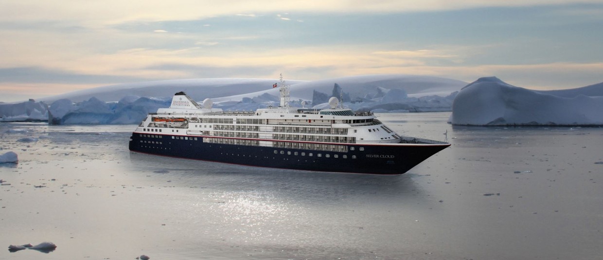
Vessel Type: Luxury Expedition Length: 157 m Passenger Capacity: 200/260 Built: 1994 Refurbished & Rebranded: 2017 After extensive refurbishment, Silver Cloud will be the most spacious and comfortable ice class vessel in expedition cruising. Her large suites, her destination itineraries and her unparalleled service make her truly special. Her five dining options will tantalise your taste buds and as 80% of her suites include a veranda, watching a breaching whale or a few cavorting penguins has never been so personal. Broad sweeping decks with multiple open spaces and a swimming pool complete what is surely the most distinctive expedition ship sailing today. A limited number of guests, particularly with just 200 in polar waters, mean that Silver Cloud has the highest space to guest and crew to guest ratios in expedition cruising. With her 18 zodiacs, possibilities are almost limitless with ship-wide simultaneous explorations. Finally, a team of 19 passionate and dedicated experts are always at hand to ensure your voyage is enhanced every step of the way. DECK 09 - Observation Lounge, Jogging Track DECK 08 - Pool, Pool Bar, Hot Rocks, The Panorama Lounge, The Connoisseur’s Corner DECK 07 - La Terrazza, The Spa at Silversea, Beauty Salon, The Library DECK 06 - Lecture Theatre, The Fitness Centre, Reception/Guest Relations, Expedition Desk DECK 05 - The Bar, Boutique, Casino DECK 04 - Main Restaurant, Le Champagne, Launderette
Highlights
• Dublin, Ireland • Loch Scavaig, Scotland • Isle of Skye, Scotland • Reykjavik, Iceland • Skjouldungen Fjord, Greenland • Nanortalik, Greenland • Qaqortoq, Greenland • Hvalsey, Greenland • Evighedsfjord, Greenland
Map